The Consortium consists of 11 multi-disciplinary partners. The project is only possible by bringing together a critical mass of internationally recognised researchers from different disciplines. The team covers the broad fields of disaster management, health sector analysis, global energy systems engineering, climate and climate policy science, water management, agricultural sciences, forest and ecosystem science, economics, goe-statistics, mathematics, informatics, remote sensing and geo-science. Most of the GEO-BENE researchers hold a degree in or have experience with economics and have received degrees in a second science field well spread over the nine benefit areas of GEO. At the same time consortium members have very close links or are directly involved in a number of policy or decision making processes, e.g. IPCC, COPs to various international conventions which are linked to the GEO initiative. We now summarize the disciplinary background, skills and research experience of the team members. In a separate section we describe the resources that will be deployed for the implementation of the project.
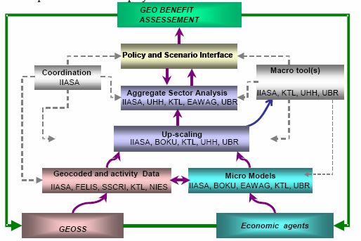
Figure: Structure of the different levels of activities within the consortium and flow of data, and information.
The figure shows the structure of the different levels of activities and of the consortium as a whole. The flowchart shows from the bottom two branches. The first branch starts with basic earth observation data provided by GEOSS, which are remotely sensed or directly observed data through sampling. Earth observation data from GEOSS as described in WP5000 is mostly geographically referenced and will be gathered and pre-processed by FELIS, SSCRI, IIASA, KTL and NIES. The data gathering, handling and pre-processing with be closely coordinated with the GEO-Secreatriat and JRC, both of which are members of the Peer Group. Timely and early delivery of geo-referenced data will ensure that models from the second branch can swiftly be up-scaled. According to the delivery plan first delivery of the assessment framework and actual quantification of a selected set of GEO-benefits on a global scale will be delivered at T8, which will mark a crucial milestone of the project. Micro-models (GEO-DIM), many of which are already existing at IIASA, BOKU, EAWAG, KTL, UB on assessment for individual or a set of GEO benefit areas will be further developed and a few will have to be newly created. Up-scaling involving mostly IIASA, BOKU, KTL, UHH and UB will allow for integrating the economic and eco-physiological modelling in the respective benefit areas along spatial and temporal scales. Interactions between benefit areas will also be analysed in the up-scaling exercise. Up-scaling of the results on the micro-level will either be performed by the use of deterministic up-scaling factors or by probabilistic geo-statistical methods. All modelling groups using a bottom up approach will be confronted with this problem. The up-scaled results then feed into aggregate sector models (GEO-SIM) or will directly linked to the GEO-MACRO model(s). GEO-SIM models will be mostly handled by IIASA in the disaster, energy, climate, weather ecosystem and biodiversity sectors, UHH will be concerned with agriculture, ecosystems biodiversity and climate, KTL with health, and EAWAG with water. The macro tools in the form of deterministic and stochastic GEO-MACRO(s) model will mostly be developed and handled by IIASA, UHH, UB. The central role of IIASA within the consortium as the coordinating organisation should allow effectiveness and efficiency the management of the scientific mission. The totality of results feed into policy and scenario interface box illustrating the dissemination and policy advice activities and linkage to assessment studies of the future of benefits form GEOSS.
As a general rule, benefit assessment, as perceived in the GEO-BENE concept must be appraised by a multitude of methodologies in order to develop tailor made tools for robust assessment of GEO-Benefits. Thus, flexibility in the selection of methodologies, use of existing and building of new tools is regarded as a strategic asset. All GEO-BENE partners are prepared to respond to this challenge. The consortium was configured in a way that such flexibility is guaranteed in order to carry out the comprehensive work plan.
The role of each the participants expressed in person month by workpackage is shown in the STREP Project Effort Form. The workpackage list and the workpackage synopsis illustrates, that every partner has specific responsibilities for one major work package. With this cross-linkage of shared responsibilities we ensure that the project is a real collaborative effort across a wide spectrum of disciplines and benefit areas.