Project Title: The value of satellite-based information for Great Barrier Reef management Collaborating GEO-BENE partners: Institute for environmental Studies (IVM), Amsterdam, the Netherlands and CSIRO, Canberra, Australia
Background
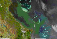
The Integrated Global Observing Strategy (2003) indicates that further investments in Global Earth Observation (GEO) are required to improve coral reef protection worldwide. However, the report does not indicate how GEO information is expected to contribute to improved coral reef protection, or what the potential benefits of GEO information are. This is problematic, since without information about the potential benefits of GEO information, additional investments are unlikely to be made.Data
qualitative information from interviews with 24 key researchers and policy makers involved in Great Barrier Reef management, quantitative estimates of the contribution of information from 50 senior policy makers and researchers, elicited through a questionnaire, existing (valuation) studies of the Great Barrier Reef, meta-analysis of coral reef valuation studies.Methods
Bayesian Decision Theory, interviews, questionnaireResults
the interviews indicate that the expected contribution of satellite observation to reef management is large because a) data are scarce (enormous size of the reef) and b) the geographical and temporal variability of land use, water quality and reef quality indicators is high. The economic value will, however, also depend on the perceived accuracy of the information, which is relatively high for land use and relatively low for parameters reflecting the condition of the reef.Status
Interviews completed, draft questionnaire being tested. Expected completion: June 2008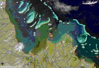 |
 |
| (a) | (b) |