Project Title: Developing a Geodata infrastructure to be used within the Geobene Project
Collaborating GEO-BENE partners: FELIS (Freiburg University), SSCRI, BOKU
Background
The Geobene project deals with large amounts of geo-referenced data and also produces models and simulations that are also geo-referenced. In order to be standards compliant we are utilizing geomtaic standards that were issued by ISO/TC211 and the OGC.
The Open Geospatial Consortium (OGC) is a well known organisation of the global geo market players worldwide. They have set up an extensive set of standards, cookbooks and recommendations that are available via http://www.opengeospatial.org (formerly known as OpenGIS).
They are defining a spatial infrastructure based on a Service Oriented Architecture (SOA). Nearly all global initiatives are adopting the ideas from OGC to form an interoperable worldwide community of geodata and services.
Now OGC and ISO, the International Standards Organisation that set the de-jure-standards are working closely together and the ISO technical committee 211 has adopted OGCs standards to form the ISO 19xxx standards family which will also be considered in this deliverable.
OGC makes use of standard web technologies like web services.
OGC defines services for the transmission of raster data like Web Mapping Service, Web Coverage service as well as for vector data (like Web Feature Service, Catalogue Services). Furthermore it defines metadata data that were adopted by ISO and culminate in the definition of metadata according to ISO 19115, which describes geospatial datasets.
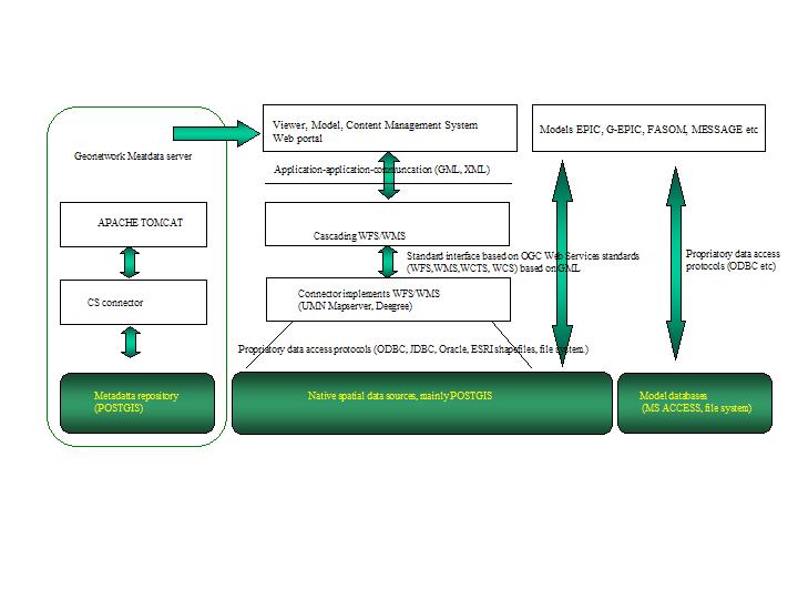
In order to follow the INSPIRE principles and in order to clearly catalogue and make available these data we have developed a Geobene system architecture based on OGC web services and standards from both the OGC and ISO/TC 211. We are running a standards compliant Open Source Metadata server used to serve both the modellers and interested researchers who can search the Geobene data pool via a standardized meta data interface based on ISO 19115 (and FAO’s open source geonetwork server).
We are describing the data models used within our simulation software (like EPIC,G-EPIC, FASOM, MESSAGE etc) and we then publish our results in WMS layers that can easily be integrated in online 3D globes.
The geobene system architecture
We also describe the GEOBENE high level system architecture that we have developed and that we are implementing at the moment. The client frontend is based on the aforementioned OGC- and ISO standards to guarantee broad acceptance and,. more important, best interoperability. The backend is based on open source software like geonetwork and postgis as well as on propriatory data sources were the used models demand it and where it is not feasible to write connectors (like EPIC).